Ex CARPATHIAN STRYDER
If you were to Google the top ten things to do in Ukraine chances are that most of the websites you click on will have listed “Hike the Carpathian Mountains”. Well that is just what the soldiers from Joint Task Force–Ukraine (JTF-U) Line of Effort 1 (LoE 1) did. The group was composed of soldiers from LdSH(RC), 2 PPCLI, 1 CER, 1 RCHA, and 16 Fd Amb. Now to say that hiking this particular mountain is a moderate to difficult hike is by most accounts an understatement. Pip Ivan stands at 2020 meters above sea level and is the third highest peak within the Chornohora Range of the Carpathians. The hike is just under 10km from base to top and is steep all the way. Ex CARPATHIAN STRYDER was the brainchild of LoE 1’s CQMS. Thanks to her hard work and planning the soldiers of LoE 1 were able to experience the hike of a lifetime.
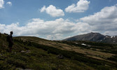
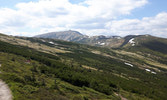
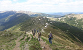
We pushed out a small advance party a day ahead of the main body to reconnoitre the base of the mountain and locate the trailhead. Also the route to the nearest medical facilities had to be timed and road conditions established. The capabilities of the medical facilities were ascertained by our medic, with the help of our language assistant. Our accommodations were in a small town very much like Banff called Bukovel. A ski town by winter, it was their off season when we arrived and was mostly quiet except for the hundreds of children and teens sent off to summer camp by their parents. The hike began on a cool morning at 1000hrs at the base of the hill in a hamlet called Dzembronia. Before we stepped off we were directed by our camp counsellor, OC LoE 1, to take a group photo. Aww man! At that point the hike began and we set off in pairs to tackle the hill. It did not take long to be completely out of breath and most of us were stopping for a “photo shoot” every 10 minutes or so. But to be completely fair, the scenery was breathtaking! The trail began as a wide gravel path that could support small vehicle traffic and as it got further up the mountain the trail became narrower and narrower, ending in a goat path. However, we were the goats this time as, I think the animals knew better than to attempt this hike. The trail split in two. There was a long way and a short way, and we had all decided at the base of the hill to take the longer “scenic” route which took us by a small water fall fed by snowmelt off the mountain. It was a busy trail as it was a long weekend in Ukraine and there were many local nationals hiking the mountain as well. Many of whom took great curiosity to the two bare chested Canadians who closely resembled the Hulk and a Sasquatch. We encountered a stretch of the hike that was one kilometer long just before the halfway mark that was a good 20-30 degree gradient. This is the point that will break anyone not prepared to carry on. Throughout this leg there were many rocky outcroppings that made for amazing photo opportunities and break areas that were much needed. They were completely utilized by the Chimo WO and his hearty crew of engineers. Oh and I cannot forget our friendly Artillery Sgt who was very quick to throw out the chirps at the beginning, but was now humbled.
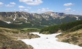
Once this leg was complete everyone was gassed and we climbed over the top of the ridge only to realize we were only halfway there! The last half of the climb took us on a much needed decline onto a horseshoe shaped ridgeline that would carry us up the final leg to the top of the mountain. From here you could take the high road or the low road, and after conferring with my fire team partner we chose the low road that takes you over the steeply inclined snow path that makes you question why we chose the “easy” route. The last kilometer of the hike takes you, once again, up a very steep trail to the top. At this point our leg muscles were aching and lungs were gasping for air. With a time of 2hrs 41min a MCpl from 2 PPCLI and a MBdr from 1 RCHA were the first to the top. Congratulations guys, well done! The remainder trickled in slowly after that and in all 26 soldiers made it to the top.
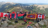
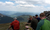
The top of Pip Ivan hosts an old abandoned Polish Meteorological Observatory. Built in 1938, it was operational for only a year and was abandoned when the Soviet Red Army entered the area. Old barbed wire and defensive positions can still be found on the mountain. We ate an IMP lunch, caught our breath and marvelled at the view. Then we produced our regimental flags and had a short photo session before beginning our descent.
The hike down was no walk in the park. Muscles throbbed on the way up, where joints screamed on the way down. We took the shorter route on the way down, and yes it was shorter, but wow it was steep! Had we chosen the opposite routes on the way up our numbers at the top would have been drastically different. The hike down took us through the woods at the lower altitudes and opened up to the highland meadows that were occupied by a few sheep and cows toting bells. We made better time going down the mountain, and looking back up at the route we had come from gave us a sense of great accomplishment. We met back up at the base of the trail and completed a foot check with minimal damage. From there we moved back to our accommodations and enjoyed the showers and soft beds.
Hiking Pip Ivan was an amazing experience. It was everything we had thought. Challenging, breathtaking, and good old fashioned fun. So for all of you reading this, if you are ever are in the position to take advantage of this hike, LoE 1 says go for it!

